
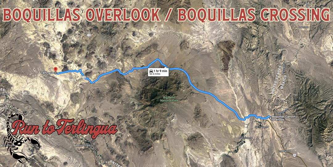
Boquillas Crossing / Overlook information: Located in the heart of Big Bend National Park right on the other side of the Rio Grande.
Crossing is open Friday - Monday from 9am - 4pm.
You can either walk across the river or for 5$ round trip, take a small boat to the other side.
Once across the river, you have the option of walking to the village (1/2 mile) or paying a local to ride on a burro, horse, or car. We suggest hopping on a burro cause, well, why the fuck not.
❗️Crossing is only accessible with a valid passport❗️.
Your driver's license WILL get you past the border crossing in Presidio though. 
𝗧𝗵𝗲 𝗕𝗶𝗴 𝗟𝗼𝗼𝗽
𝘈 𝘙𝘰𝘺𝘢𝘭 𝘊𝘪𝘳𝘤𝘶𝘪𝘵 𝘰𝘧 𝘛𝘦𝘹𝘢𝘴’ 𝘉𝘦𝘴𝘵 𝘙𝘰𝘢𝘥𝘴-𝘈𝘭𝘭 𝘪𝘯 𝘖𝘯𝘦 𝘋𝘢𝘺
𝗦𝘁𝗮𝗿𝘁: 𝗙𝘂𝗲𝗹 𝗨𝗽 𝗶𝗻 𝗧𝗲𝗿𝗹𝗶𝗻𝗴𝘂𝗮
- Take River Road (FM 170) for 64 miles to Presidio.
Watch for wildlife, falling rocks, and road debris.
If you’re unfamiliar with River Road, take it easy—this road is unforgiving.
- In Presidio, turn right onto Hwy 67 and ride 60 miles to Marfa.
⛽️𝗥𝗲𝗳𝘂𝗲𝗹 𝗶𝗻 𝗠𝗮𝗿𝗳𝗮
- Just before Ft. Davis, veer left onto Hwy 166 and hit the Davis Mountains Loop.
*𝘔𝘤𝘋𝘰𝘯𝘢𝘭𝘥 𝘖𝘣𝘴𝘦𝘳𝘷𝘢𝘵𝘰𝘳𝘺 𝘪𝘴 𝘢𝘭𝘰𝘯𝘨 𝘵𝘩𝘪𝘴 𝘳𝘰𝘶𝘵𝘦—𝘴𝘵𝘰𝘱 𝘣𝘺 𝘢𝘯𝘥 𝘤𝘩𝘦𝘤𝘬 𝘰𝘧𝘧 “𝘬𝘪𝘤𝘬𝘴𝘵𝘢𝘯𝘥𝘪𝘯𝘨” 𝘰𝘯 𝘵𝘩𝘦 𝘩𝘪𝘨𝘩𝘦𝘴𝘵 𝘩𝘪𝘨𝘩𝘸𝘢𝘺 𝘪𝘯 𝘛𝘦𝘹𝘢𝘴*
🚨 Heads up: Hwy 166 has tight hairpin turns and uneven sweepers. Your suspension will get a workout—stay aware, loose, and in control.
- From the Observatory, take Hwy 118 back to Alpine and enjoy the ride.
Watch your speed as you get closer to Alpine—law enforcement is known to keep an eye out.
⛽️𝗙𝘂𝗲𝗹 𝗨𝗽 𝗶𝗻 𝗔𝗹𝗽𝗶𝗻𝗲
Finally, slow-roll your bad self back into town on Hwy 118 South. Kickstand down, boots in the sand—the beer’s cold. 🍻
⛽️𝗙𝘂𝗲𝗹 𝗨𝗽 𝗶𝗻 𝗔𝗹𝗽𝗶𝗻𝗲
Finally, slow-roll your bad self back into town on Hwy 118 South. Kickstand down, boots in the sand—the beer’s cold. 🍻
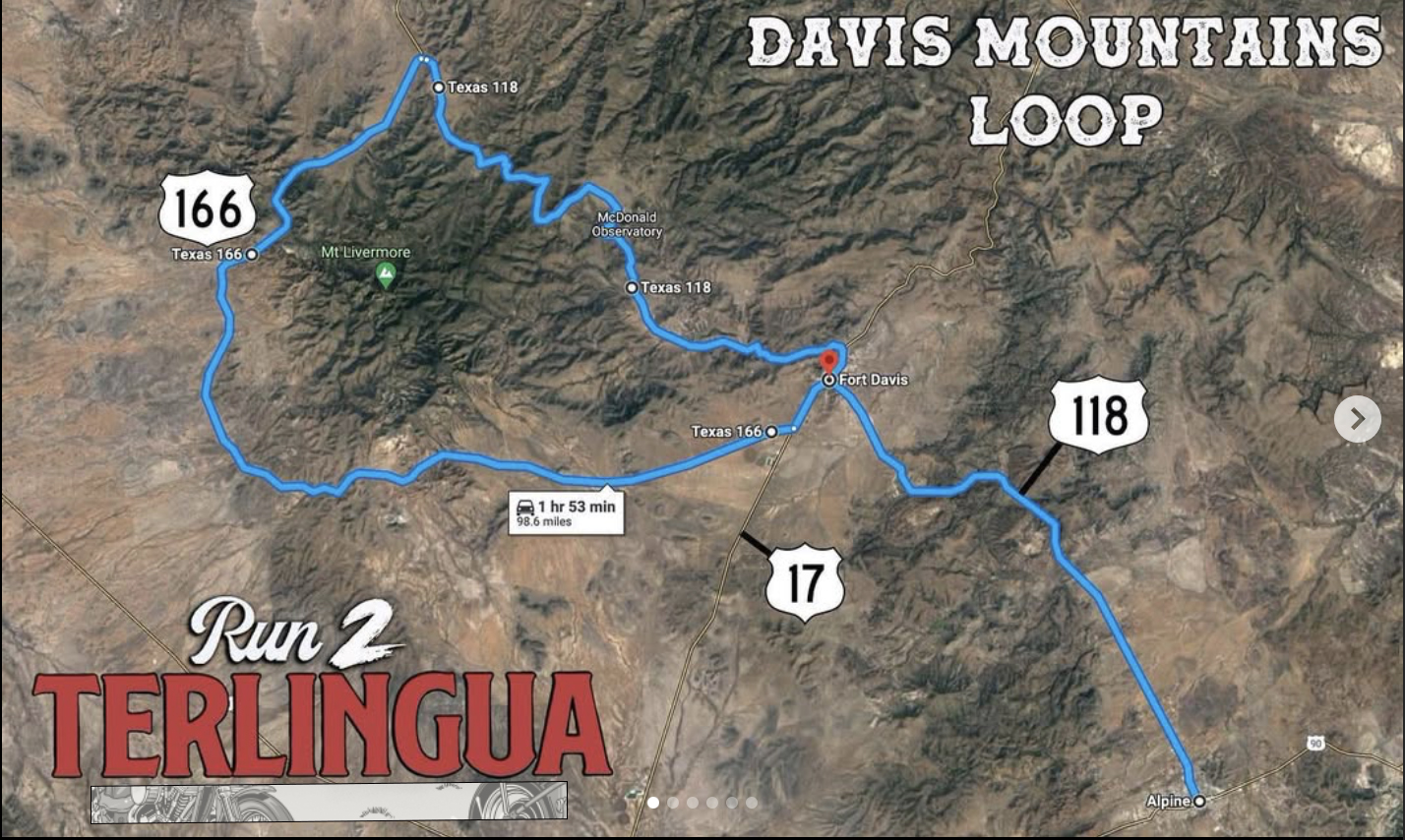
Davis Mountains Loop: This loop winds you around Mount Locke, Madera Canyon, Sawtooth Mountain, and Mc Donald Observatory.
*These are more advanced roads and will bounce your suspension around turns. Make sure you’re rolling stiff if you wanna jam around the loop with heavy throttles.*
If you want to save time and rip straight to the Scenic Loop from Alpine. Head up 118 North and fuel up in Fort Davis. It’s a loop so flip a coin on which way you wanna start, keep it interesting.
-Check out the Summit of Mount Locke on 118. It’s the highest point on Texas Highways at 6,791 feet. *Aka McDonald Observatory*
-If your heading in from up north, 17 is a ripper of a road and and throws you right into 166 after Fort Davis.
- There are two routes you can take after the loop. 118 south is a beautiful road and takes you strait into Terlingua. It’s about an hour 45 ride from Fort Davis and allows you to kick back and enjoy the ride in.
- Second route runs you down 67 South through Marfa. Continue down 67 through the mountains to Presidio where you can run 170 backwards all the way to Terlingua. Its desolate out there on 67 and you can hit some good cruising speeds. Adds an extra hour or so to your travel time into town. It’s a cool ride if you don’t mind the extra miles
- This route takes you past a mountain that strangely resembles the silhouette of Abraham Lincoln. Located between Marfa and Presidio on Hwy67. Check it out, there’s a spot to pull over.
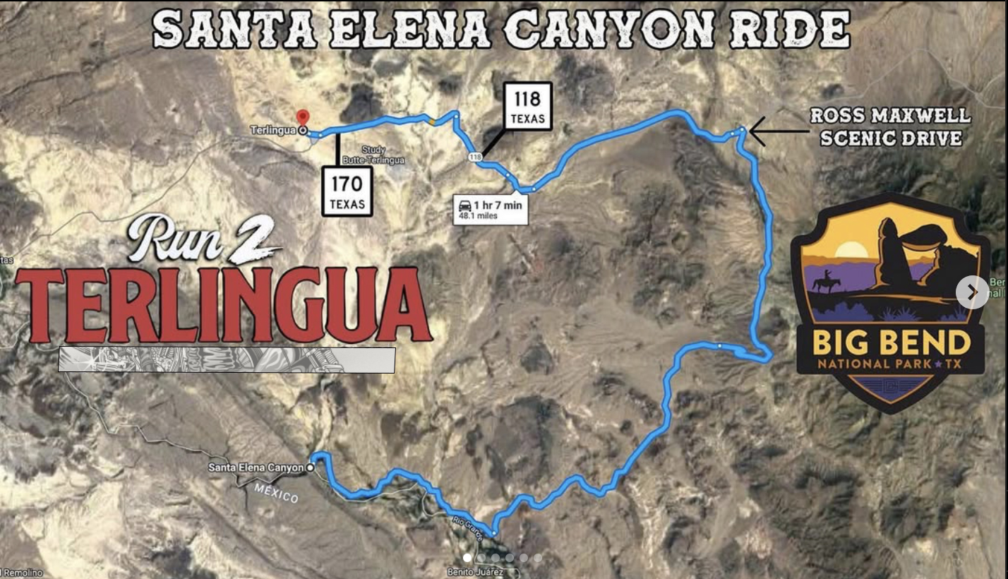
Santa Elena Canyon Ride: With cliff than span up to 1,500 feet, the Santa Elena Canyon is as massive as it is majestic. A short little nature trail guides you right into the canyon where you’re met with sand under your boots and the Rio Grande.
Route from Terlingua: Just like the Chisos Basin, Hook a left on 170 out of Terlingua and take that all the way down to 118. 118 turns into Big Bend National Park and ride that on through. Its approximately 9 miles from the entrance to big bend to the Ross Maxwell Scenic Drive. Hook a right and take that road all the way down to the canyon. There will be signs directing you on the big bend roads, keep a look out for them.
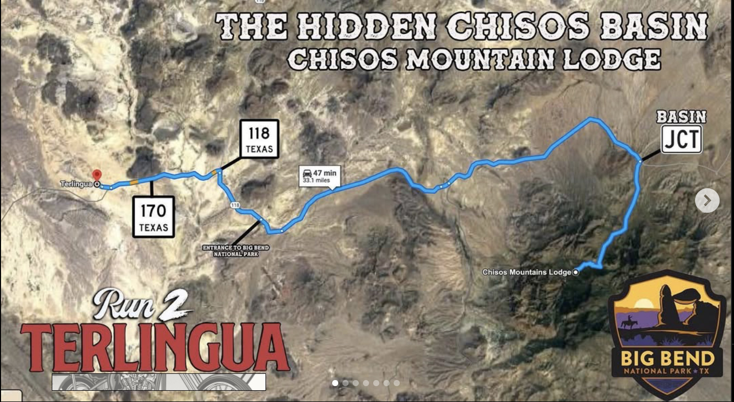
Chisos Mountain Lodge: Located inside Big Bend National Park. The Lodge sits at an elevation of 5,400ft. Packed with nearly 20 miles of hiking trails that trek you up a little over 7,000ft.
Route information from Terlingua: Take a left on 170 out of Terlingua and take it all the way until you hit 118. Hook a right on 118 and ride that all the way into the National Park. It’s approximately 25 miles from the entrance to the park to Basin Junction if you want to reset your odometers. Hook a right at Basin Junction and ride that sucker all the way in.
*Heads up, Basin Junction has multiple hair pen turns as you close into the Chisos Basin, some at a downhill slope. Bar Mounted GPS will help prepare you for these low speed puckers. Nice and easy keeps it breezy*